 Following are some sources for additional information on hazard risks your community may face. For details on how to use this information to help protect your community, see where to use additional information on coastal hazard risks.
Understanding Your Community’s Exposure
The first step towards making your community more resilient to disasters is understanding and prioritizing its risks: the Mississippi-Alabama Sea Grant Consortium has put together a very useful tool called the Coastal Resilience Index to help you do just that.
Hurricane Probability
For the latest (April, 2009) statistics on the likelihood of your county being struck by a hurricane, see The United States Landfalling Hurricaneor Web Project.
Shoreline Change History
The Geological Survey of Alabama (through the Alabama Department of Conservation and Natural Resources Lands Division Coastal Section’s Coastal Zone Management Program) uses GIS modeling of a comprehensive historic shoreline dataset to determine rates of shoreline change. Although not currently available online, these data and shoreline change reports can be requested through these agencies.
In addition to more recent State efforts, the U.S. Geological Survey Open File Report 2004-1089 also addresses historical shoreline change using shorelines dated between about 1849 and 2001.
Communities seeking more information on shoreline change and the risks that come with it can download a PDF of the Heinz Center’s Evaluation of Erosion Hazards.
Sea Level Rise Data and Projections
While the causes and future rates are still being debated, there is a general scientific consensus that sea levels are rising. Consequently, the effects of future, higher, sea levels should be considered when making siting decisions. For more information on current predictions for sea level rise, see the following:
- A consortium of groups including The Nature Conservancy and the Gulf of Mexico Alliance have created a sea level rise site with detailed information spots along the Gulf Coast.
- The U.S. Global Change Research Program’s Online Resource Library provides access to data and information on climate change research, adaptation/mitigation strategies and technologies, and global change-related educational resources.
- The U.S. Environmental Protection Agency is generally accepted as an authority on sea level rise trends. See their Sea Level Rise Reports and Coastal Zones and Sea Level Rise pages.
- The National Oceanographic and Atmospheric Administration’s Sea Levels Online graphs recent trends from different parts of the Alabama coastline.
- The International Panel on Climate Change (IPCC) has extensive information on sea level rise available on their frequently updated web site.
- Coastal communities can find general suggestions for means of adapting to rising sea levels and climate change in Preparing for Climate Change: A Guidebook for Local, Regional and State Governments.
- The Florida Institute of Technology has assembled a new library of sea level and coastal climate adaptation.
Storm Surge
Storm surge is water that is pushed toward the shore by winds. This advancing surge combines with normal tides to create the storm tide, which can increase the effective sea level 25 feet or more. Wind driven waves are added on top of the storm surge, creating tremendous potential for extensive storm damage.
- For maps showing your community’s estimated storm surge risk, see NOAA’s National Coastal Data Development Center’s Coastal Risk Atlas Interactive Viewer and Assessment Tool (look under the “Hazards Vulnerabilities” tag in the right column).(look under the “Hazards Vulnerabilities” tag in the right column).
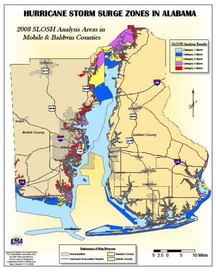
- The U.S. Army Corps of Engineers has hurricane surge inundation maps for Alabama based on data provided by NOAA. See this map (created by the Alabama Emergency Management Agency) of the projected inundation for the state.
Coastal Inundation
With continuing sea level rise, more and more areas are at risk of flooding or being damaged by storm surge. Unfortunately, figuring out what areas are going to flood in the future is even trickier than determining which are most at risk now. NOAA has created a Coastal Inundation Toolkit with information coastal inundation is and how to address it. Also see their Mapping Coastal Inundation Primer (PDF, 1.4 MB).
Wind Risk
For projections on approximate wind speeds in your community during different categories of hurricanes, see National Weather Service’s Hurricane Preparedness website.
For maps showing your community’s estimated wind envelope, see NOAA’s National Coastal Data Development Center’s Coastal Risk Atlas Interactive Viewer and Assessment Tool (look under the “Hazards Vulnerabilities” tag in the right column).
Local Knowledge
In most communities, there are areas that flood that are not mapped as flood zones on the community’s Flood Insurance Rate Maps (FIRMs). Community decisions about land use in floodplains should be based on the actual floodplain, which should be determined from all available information, including the FIRM’s data, relevant parts of the Flood Insurance Study, and your community’s experiences. During and immediately after storm events, your community can record the true (as opposed to modeled) extent of a storm. This can be done in many ways—if aerial photographs are available, these can be used, as can physically recording the extent of floodwaters (high-water marks) during the peak hours of a storm event or soon after the storm when the evidence is still visible.
Other Sources of Hazard Information
- The NOAA Coastal Service Center’s Digital Coasts website, which couples data and tools together to help inform coastal decision makers. See their Digital Coasts in Action page for examples on how some communities (including several in the region) are using the site.
- The National Assessment of Coastal Vulnerability to Sea-Level Rise: Preliminary Results for the U.S. Gulf of Mexico Coast provides information on coastal vulnerability as they relate to geomorphology, shoreline slope, tide range, wave height, and shoreline change rates.
- The iCAT Damage Estimator is a web tool that shows storms from 1900 to the present with damage projections for how much damage each storm would cause if it were to hit today (read our post on the iCAT Damage Estimator).
Where to Use Additional Information on Coastal Hazard Risks
As your community’s understanding of local flood and erosion risks improves, so do your chances of successfully addressing them. For example, more detailed information on areas prone to flooding, erosion, or storm damage will allow your community to better plan for development in its master plan, more efficiently prepare for emergencies in its disaster response plan, and more effectively help educate its citizens as to the real risks they face. Following are some areas where your community can use its newly found hazard information.
- Planning
- Regulations and Development Standards
- Infrastructure
- Emergency Services
- Education and Outreach
![]() * Your community needs only 500 points to qualify for reduced flood insurance premiums through the Community Rating System (CRS). For more information (including how to apply for the CRS program), see our Community Rating System (CRS) primer.
* Your community needs only 500 points to qualify for reduced flood insurance premiums through the Community Rating System (CRS). For more information (including how to apply for the CRS program), see our Community Rating System (CRS) primer.
Notes from the folks at CRS:
“Local governments preparing floodplain management plans or hazard mitigation plans should seek and utilize flood risk information from Federal, State and Regional agencies. For coastal communities this should include information on their shoreline change history, sea-level rise and storm surge. More credit is provided to local governments that research and use information on other risks such as high winds, subsidence and ground movement. In CRS that effort is credited under Activity 510 Floodplain Management Planning.”